Bot. Bull. Acad. Sin. (2002) 43: 69-75

Yang et al. — Earthquake-caused Landslide and grey prediction for vegetation recovery

Chi-Chi Earthquake-caused Landslide: grey prediction model for pioneer vegetation recovery monitored by satellite images

Chi-Ming Yang1,*, Jan-Chang Chen1, Lan-Lin Peng1, Jr-Syu Yang2, and Chang-Hung Chou1

1Institute of Botany, Academia Sinica, Nankang, Taipei, Taiwan 11529, Republic of China

2Department of Mechanical Engineering, Tamkang University, Tamshui, Taipei County, Taiwan 25134, Republic of China

(Received May 14, 2001; Accepted August 2, 2001)

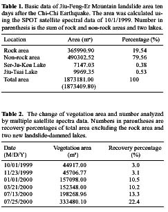
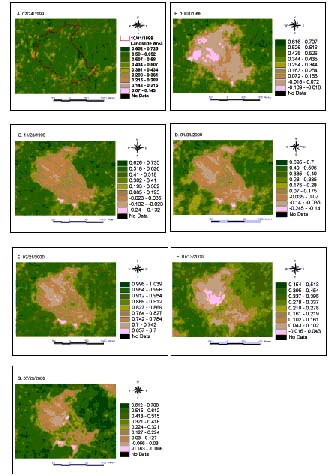
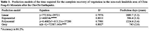
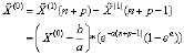
Abstract. We applied multiple SPOT satellite remote sensing data to evaluate the recovery rate of vegetation in the Chiu-Feng-Er mountain landslide area after the Chi-Chi Earthquake. The grey theory was also applied to predict the time required for pioneer vegetation to completely reclaim the non-rock landslide area, and this was compared with the results of linear, exponential, and polynomial regression analysis. While complete recovery of vegetation may take 5.2, 1.6 and 3.4 years predicted by the linear, exponential, and polynomial regression analyses, respectively, it may take 2.0 years according to grey analysis. On the basis of ground investigation, the recovery process of pioneer vegetation in Chiu-Feng-Er Mountain landslide may follow the equation of the grey prediction model, i.e. x(k+1)=72387.143e0.4704. This recovery process exhibited a lag phase of approximately two months.

Keywords: Earthquake-caused landslide; Grey prediction model; Pioneer vegetation; Recovery; Satellite images.

Introduction

At 1:47 on the morning of September 21, 1999, Taiwan's largest earthquake (ML=7.3, Mw=7.7) in the past hundred years struck the central part of this island nation near the small town of Chi-Chi, leading to extensive surface ruptures and severe destruction in most the towns of Nantou and Taichung Counties (Ma et al., 1999; Kao and Chen, 2000). The Chiu-Feng-Er Mountain landslide area is the fourth largest of all Chi-Chi Earthquake-caused landslide areas (Chen and Lee, 1999). Very little vegetation remained in the area after the quake.

Satellite remote sensing data has been used to monitor long-term changes in vegetation (Oechel and Reid, 1984; Jakubauskas et al., 1990), photosynthesis of terrestrial plants (Field et al., 1994), changes in canopy structure and density (Malanson and Trabaud, 1987), recovery of primary production (Specht, 1981; Tucker and Sellers, 1986), regrowth rate and biomass production of the forest (Viedma et al., 1996), rate and model of recovery (Viedma et al., 1997), and other aspects during the ecological recovery process following the fires. The immediate damage wrought by the earthquake on the forest (Allen et al., 1999) and the recovery of earthquake-caused landslide area have been studied (Garwood et al., 1979). However, no report using satellite images to monitor the ecological recovery process in a landslide area after a disastrous earthquake is yet available.

The grey system theory was first presented in China. Thereafter it has been increasingly and widely applied in many research fields to deal efficiently with an uncertain system through grey methodologies, including grey generation, grey relational analysis, grey modeling, grey prediction, grey decision making, and grey control (Deng, 1982 and 1989). A grey prediction model GM(1,1) is the main component of the grey system theory and has been used in most research (Deng, 1989). An increasing number of forecasting studies in the life sciences are beginning to apply grey theory to analyzing uncertain systems. Examples include grain yields (Luo and Zhang, 1991), vegetable yields (Ma et al., 1996; Long, et al., 1993), crop breeding (Guo, 1994; Zeng et al., 1993), choosing the best serum markers of liver fibrosis (Chen and Tan, 1995), epidemic diseases (Wei, and Xie, 1994), population growth (Jin and Tang, 1994), and changes in the ecological environment (Che and He, 1993; Yang et al., 1999).

This study considered regression analysis and the grey theory to predict the pioneer vegetation recovery rate, monitored by multiple SPOT satellite remote sensing data obtained during the first year following the Chi-Chi Earthquake. The pioneer vegetation includes the rare residual vegetation after the quake and the new vegetation.

Materials and Methods

Study Area

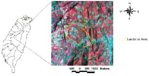
Chiu-Feng-Er Mountain is located in Kow-Hsin-Shiang of Nantou County (Figure 1). The surface soil and rock along the dip slope of the southern side of Chang-Su-

*Corresponding author. Tel: 886-2-27821258 ext. 308; Fax: 886-2-27827954; E-mail: cmyang@gate.sinica.edu.tw


Botanical Bulletin of Academia Sinica, Vol. 43, 2002

Figure 1. Geographic location of Chiu-Feng-Er Mountain landslide area after the Chi-Chi Earthquake.

Shiang Mountain slid from northwest to southeast, for more than 1 km, into the 500 m deep valley situated between the northern side of Chiu-Feng-Er Mountain and the southern side of Chang-Su-Shiang Mountain. This resulted in a landslide area that blocked the upstream progress of the Nankang River and formed two new landslide-dammed lakes, named Ser-Chu-Ken Lake and Chiu-Tsai Lake. A huge rock area was exposed in the northwestern part of the landslide area (Pan et al., 1999).

Satellite Data

Seven sets of orthorectified SPOT satellite imagery (level 10) were purchased from the Center for Space and Remote Sensing Research, National Central University. The data were for the dates 7/23, 10/1, and 11/23 of 1999, and 1/1, 3/12, 7/13, and 7/25 of 2000. A first set, taken two months before the Chi-Chi Earthquake, was employed as control. All imagery was cloud-free.

Image Processing

Hybrid classification including supervised and non-supervised classification methods was used to optimize the classification of ground vegetation in the landslide area and to promote classification accuracy. Since only two categories were classified, vegetation and bare ground, accuracy of this study exceeded 95% according to the classification error or confusion matrix of classification accuracy assessment. This matrix is not presented in the paper because it is not necessary. The ground was also bimonthly investigated to confirm the satellite remote sensing data (data not shown). Normal Difference Vegetation Index (NDVI) was defined by the equation (NIR-R)/(NIR+R).

Regression Analysis

Linear, exponential, and polynomial regression analyses were conducted using the SAS (statistic analysis system) program.

Grey Prediction

The single series first-order linear dynamic model GM(1,1) of the grey system theory (Deng, 1989) was employed to develop the grey prediction model for the time required for pioneer vegetation to recover completely in the non-rock landslide area. The time data series of tested compounds, designated as X(0)(i) and an X(0)(i) series, was established to compute the corresponding first-order accumulated generating operation (I-AGO). The AGO of grey generating is to accumulate the new data by series of original data. The last equation can be used to calculate the prediction value.

The grey operation used in this research is as follows:

(1) AGO (Accumulated Generating Operation)

Let X(0) be a nonnegative original data sequence,

X(0)(k)=( X(0)(1), X(0)(2),............ X(0)(n))

(1)

Taking AGO on X(0),

We obtain a first order AGO sequence X(0),

(2) Mean generating operation , Z(1)(k)

(2)

(3) Grey differential equation of GM(1,1)

(3)

Where a and b are called the developing coefficient and the grey input, respectively

(4) Whitening equation of the grey differential equation is


Yang et al. — Earthquake-caused Landslide and grey prediction for vegetation recovery

(4)

Define matrix , B, and Yn as:

(5)

(6)

(7)

The solution of the whitening differential equation (4) is

(8)

Where the parameter p is the prediction step size.

(5) Take I-AGO (Inverse Accumulated Generating Operation) on X(1)

The corresponding IAGO sequence X(0) is denoted as X(0) =I-AGO*X(1)

I-AGO:

(9)

whereis the predicted value of

Results and Discussion

Basic Data

The Chi-Chi Earthquake severely destroyed the original vegetation and terrain of the Chiu-Feng-Er Mountain area, causing a landslide area and erecting two new landslide-dammed lakes in the south. Based on the 10/1/1999 satellite remote sensing data, the Chiu-Feng-Er Mountain landslide area was estimated as covering about 1,856,065 m2, equivalent to about 185.6 h, excluding the new landslide-dammed lakes, and 1,873,181 m2 by including them (Table 1). The denuded rock area, exposed completely after the quake, covers about 365,991 m2, or about 19.54% of the total landslide area. The areas of Ser-Chu-Ken Lake and Chiu-Tsai Lake are 7,147 m2 and 9,969 m2, and occupy 0.38% and 0.53% of the total landslide area, respectively. The remaining non-rock area extends about 1,490,302 m2 and accounts for approximately four-fifths of the total area.

The landslide area in this study is at least 3% larger than the 180 h estimated by the Bureau of Soil and Water Conservation, Council of Agriculture, Executive Yuan (Chen and Lee, 1999). The Chiu-Feng-Er Mountain landslide area obviously belongs to secondary succession (Flaccus, 1959) since it was totally covered by vegetation before the Chi-Chi quake, with more than 97.5% of the landslide area becoming denuded subsequently.

A denuded rock area of about 36.5 h was formed in the northwest (Table 1). During the first nine months of recovery, only individual small plants were evident in this area and no vegetation developed here, as in other parts of the landslide. Vegetation recovery in the exposed rock area is not expected very soon.

Vegetation Recovery

The original vegetation of the Chiu-Feng-Er Mountain area was nearly totally destroyed, with only about 2.4% of it remaining out of a total area of 44,917 m2. This is evident in the satellite remote sensing data of 10/1/1999 (Table 2). Even though the marginal frame of the landslide area changed considerably within the first two months after the quake, the total area of vegetation increased, from 44,917 m2 on 10/1/1999 to 45,707 m2 on 11/23/1999, or about 1.8%. The vegetated area occupied 3.0 and 3.1%, respectively, of the total landslide non-rock area excluding the two landslide-dammed lakes, on those dates. The total vegetation area subsequently increased rapidly to 157,098 m2 on 1/1/2000, 152,348 m2 on 3/21/2000, 198,269 m2 on 7/13/2000, and 333,480 m2 on 7/25/2000. The recovery


Botanical Bulletin of Academia Sinica, Vol. 43, 2002

Figure 2. The spatial distribution of NDVI in the Chiu-Feng-Er Mountain landslide area monitored by multiple SPOT satellite data after the Chi-Chi Earthquake.


Yang et al. — Earthquake-caused Landslide and grey prediction for vegetation recovery

tial and polynomial regression were very close, i.e. 0.7976, 0.8011, and 0.7981, respectively. The average accuracy of a grey equation is 80.2%. The R value and grey accuracy are not comparable since they are different characteristics.

According to the regression equations, the re-establishment of vegetation may take 1890, 586, and 1224 days, equivalent to 5.2, 1.6, and 3.4 years, respectively, to completely cover the non-rock area. However, the same process may take 743 days or 2.0 years, according to analysis by the grey system theory. Conservatively and safely speaking, it may take 1.6-5.2 years to completely recover. However, of the four prediction models, it is claimed that the grey system theory offers the most precise and accurate forecasting (Deng, 1989). If that is the case, the total recovery of vegetation in the Chiu-Feng-Er Mountain landslide area will require two years, with a lag phase of about two months. In this situation, only time will tell which model is the best.

Disturbances are usually considered as infrequent events that disrupt the balanced state of an ecosystem, leading to its complete transformation (White and Pickett, 1985). Undoubtedly, the original ecological balance in the Chi-Chi Earthquake landslide area was completely disturbed. This study predicts that the pioneer vegetation will be established in about two years, enabling total recovery of the non-rock portion of the Chiu-Feng-Er Mountain landslide area.

Acknowledgements. This study was financially supported by a Project of the Ecological Research on the Earthquake Landslide Area, of Academia Sinica, Nankang, Taipei, Taiwan. We would like to express our gratitude to the Resource Inventory Section, Agricultural and Forestry Aerial Survey Institute, Bureau of Forestry, Council of Agriculture, Executive Yuan of the Republic of China for its help in many aspects.

Literature Cited

Allen, R.B., P.J. Bellingham, and S.K. Wiser. 1999. Immediate damage by an earthquake to a temperate montane forest. Ecology 80: 708-714.

Che, K.J. and H.Y. He. 1993. Grey relational analysis and topological prediction on ecological environment. J. Grey Sys. 5: 147-162.

Chen, C.C. and M.C. Lee. 1999. The damage of soil and water conservation facilities after Ji-Ji Earthquake in Taiwan. Monograph of Symposium on the Damage Investigation of Ji-Ji Earthquake. November 5-6, 199, Tainan, Taiwan, pp. D25-D30.

percentage increased from 3% to 10%, then to 13%, and then to 22%. Thus, more than 22% of the non-rock area was now covered by pioneer plants, nine months after the Chi-Chi Earthquake. Apparently, a lag phase occurred during the vegetation recovery process.

The spatial distribution of vegetation's NDVI demonstrated that most of the pioneer vegetation is distributed in the central part of the landslide area and spread from there (Figure 2), and that the recovery process of pioneer vegetation in the Chiu-Feng-Er Mountain landslide area underwent approximately a two-month lag phase. The length of the lag phase may be influenced by a combined effect of the macro- or micro-environmental conditions in the landslide area. Although the spatial distribution and area of each vegetation (which should be big enough) can be recognized by satellite data, the ground resolution of satellite limits the recognition power for the plant species in each vegetation in this study.

Malanson and Trabaud (1987) monitored the recovery characteristics of a Quercus coccifera garrigue forest at 3, 9 and 33 years following the latest fire. They found that the overall biomass increased rapidly at 3 and 9 years, and decreased slightly at 33 years. They also found that the canopy closed during the early post-fire years, then reopened in later years, in the absence of fire. This implied a lag period of about two years for long-term recovery of the ecosystem (or at least 10 years). However, they did not provide any data to show that a short lag phase existed during the first year of the short-term recovery. In our study, multiple satellite imagery was effective enough to observe a short lag phase (about two months) in the very early post-quake months. Nevertheless, it is still unknown whether the recovery process of other new ecosystems, such as those caused by fires, includes a short lag phase during the early period. In general, the rate of change in ecosystem characteristics is not always linear, and it may be difficult to extrapolate from measurements made during the early period of the recovery process. Moreover, ecosystem characteristics do not necessarily recover at similar rates (Hill, 1987).

Grey Prediction Model

The prediction model equation for the linear, exponential, and polynomial regression, and the grey system for the pioneer vegetation recovery rate was as follows: y = 772.81x + 29721, y = 46834e0.0059, y = 0.4682x2 + 613.21x + 37280 and x(k+1) = 72387.143e0.4704, respectively (Table 3). The values of R square for the linear, exponen


Botanical Bulletin of Academia Sinica, Vol. 43, 2002

Chen, Y.K. and X.R. Tan. 1995. Grey relational analysis on serum markers of liver fibrosis. J. Grey Sys. 7: 63-74.

Deng, J.L. 1982. Control problems of grey systems. Sys. Control Lett. 5: 288-294.

Deng, J.L. 1989. Introduction to grey system theory. J. Grey Sys. 1: 1-24.

Field, C.B., J.A. Gamon, and J. Penuelas. 1994. Remote sensing of terrestrial photosynthesis. In E.D. Schulze and M.M. Caldwell (eds.), Ecophysiology of Photosynthesis. Ecological Studies, Vol. 100, Springer-Verlag, Berlin, pp. 511-528.

Flaccus, E. 1959. Revegetation of landslides in the White Mountains of New Hampshire. Ecology 40: 692-703.

Garwood, N.C., D.P. Janos, and N. Brokaw. 1979. Earthquake-caused landslides: a major disturbance to tropical forests. Science 205: 997-999.

Guo, R.L. 1994. Conception on grey crop breeding science. J. Grey Sys. 6: 257-270.

Hill, A.R. 1987. Ecosystem stability: some recent perspectives. Prog. Phys. Geogr. 2(3): 315-333.

Jakubauskas, M., K.P. Lulla, and P.W. Mausel. 1990. Assessment of vegetation change in a fire-altered forest landscape. Photogramm. Eng. Remote Sens. 56: 371-377.

Jin, K.Z and Q.H. Tang. 1994. Grey prediction of the population density of wheat armyworm. J. Grey. Sys. 6: 135-140.

Kao, H. and W.P. Chen. 2000. The Chi-Chi earthquake sequence: active, out-of-sequence thrust faulting in Taiwan. Science 288: 2346-2349.

Long, X.G., H.Y. Li, and F.G. Jia. 1993. Analysis and envelope grey prediction in fruits and forest yields. J. Grey Sys. 5: 163-170.

Luo, J.J. and Z.Q. Zhang. 1991. Grey periodic modified prediction for grain yield. J. Grey Sys. 3: 221-226.

Ma, K.F., C.T. Lee, Y.B. Tsai, C.Y. Wang, and K.L. Wen. 1999. The 1999, Chi-Chi, Taiwan (ML=7.3, Mw=7.7) earthquake-large surface displacements on an inland Thrust-fault. Monograph of Symposium on the Damage Investigation of Ji-Ji Earthquake. November 5-6, 199, Tainan, Taiwan, pp. II6-15.

Ma, Y.J., Z.Z. Su, and G.G. Ma. 1996. Grey decision-making on vegetable production. J. Grey Sys. 8: 189-196.

Malanson, G.P. and L. Trabaud. 1987. Post-fire development of canopy structure in a Mediterranean shrub. Quercus coccifera L. Phys. Geogr. 8: 266-274.

Oechel, W.C. and C.D. Reid. 1984. Photosynthesis and biomass of chaparral shrubs along fire-induced age gradient in southern California. Bull. Soc. Bot. Fr. 131: 399-409.

Pan, Y.W., J.J. Liao, J.C. Yang, A.B. Huang, and J.J. Dong. 1999. Some damaged hydraulic facilities and adverse colluvial dams after Ji-Ji Earthquake, 1999. Monograph of Symposium on the Damage Investigation of Ji-Ji Earthquake. November 5-6, 199, Tainan, Taiwan, pp. C01-C20.

Specht, R.L. 1981. Primary productivity in Mediterranean-climate ecosystems regenerating after fire. In D.W.F. di Castri and R.L. Specht (eds.), Mediterranean-Type Shrublands. Elsevier, Amsterdam, pp. 257-267.

Tucker, C.J. and P.J. Sellers. 1986. Satellite remote sensing of primary production. Intl. J. Remote Sens. 7: 1395-1416.

Tucker, C.J., J.R.G. Townshend, and T.E. Goff. 1985. African land-cover classification using satellite data. Science 227: 369-375.

Viedma, O., J. Melia, D. Segarra, and H.J. Garcia. 1997. Modeling rates of ecosystem recovery after fires by using Landsat TM data. Remote Sen. Environ. 61: 383-398.

Viedma, O., J. Melia, J. Garcfa-Hara, and D. Segarro. 1996. Monitoring forest regrowth rates after fire with multitemporal Landsat-TM imagery, EARSEL Advances in Remote Sensing. Remote Sensing and GIS Applications to Forest Fire Management. 4(4): 145-154.

Wei, S.R. and Y.F. Xie. 1994. Grey prediction for notifiable diseases. J. Grey Sys. 6: 59-68.

White, P.S. and S.T.A. Pickett. 1985. Natural disturbances and patch dynamics: an introduction. In S.T.A. Pickett and P.S. White (eds.), Ecology of Natural Disturbance and Patch Dynamics. Academic Press, London, pp. 3-13.

Yang, C.M., J.S. Yang, C.K. Yang, and C.H. Chou. 1999. Long-term ecological research chlorophyll cycling in the Yuanyang Lake Nature Preserve I. the grey prediction models on chlorophyll degradation of Chamaecyparis var. formosana leaf. Photosynthetica 37: 499-508.

Zeng, B.Y., Q.G. Li, A.F. Li, C.Q. Zhang, and H.L. Chen. 1993. Grey clustering for wheat parents crosses. J. Grey Sys. 5: 35-242.


Yang et al. — Earthquake-caused Landslide and grey prediction for vegetation recovery